 Amplibee

What is ArgenFields?
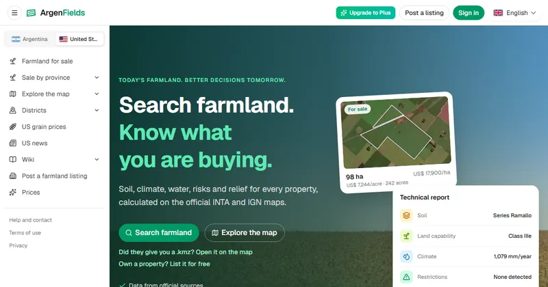
ArgenFields is a farmland research site for Argentina and the contiguous United States. It combines maps and technical reports so you can read a property's soil, climate, water, terrain and risks before a visit or a purchase.
The home page says the data is calculated on official maps such as INTA and IGN for Argentina, and that it does not replace a survey on the ground.
What does a report cover?
A report reads soil, climate, water, terrain, land use, mapped risks and logistics for a parcel or a field boundary you define, with the public sources and data coverage shown.
- The home page shows a sample report with soil series, land capability, yearly rainfall and restrictions
- US reports also show indicative cash-rent and land-value ranges, an initial solar-potential screen and dated regional grain prices with basis, according to the submission
- County pages and soil-series articles add regional context
Which data sources does it use?
For Argentina, the submission names INTA, IGN and other cited sources. For the United States it names USDA NRCS SSURGO and NCCPI, NASS, USGS and FEMA where available.
The home page lists data from official sources and coverage throughout Argentina, with state and county data for the US.
What can I do on the map?
You can search by district, town or keyword, switch map layers, compare properties side by side and open a .kmz file a seller sent you.
Layers include cadastre, soil, water, restrictions and risks, crops, climate and terrain, according to the site. Owners can also list a property for sale for free.
Is it free?
Partly. The submission says the map, regional pages and soil wiki are free, and full reports have a weekly allowance on the free plan. Paid plans add capacity.
The home page links to a prices page and an Upgrade to Plus option. It does not state plan prices.
Alternatives to ArgenFields
Farmland research usually means gathering soil maps, climate data and listings from separate public sources. ArgenFields puts maps, parcel reports and regional pages for Argentina and the US in one site.
- AcresA land analysis platform with U.S. parcel data, soil maps and comparable sales, with a free tier.acres.com ↗
- AcreValueGranular's farmland site with a valuation model, soil maps and production history.acrevalue.com ↗
- Land idMapping and soil report tools for farmers and landowners.id.land ↗
How ArgenFields compares
| Option | Best for | Trade-off |
|---|---|---|
| ArgenFields | Reading soil, climate, water, terrain and mapped risks for a parcel before a field visit or a farmland decision | Indicative data only, and full reports are limited by a weekly allowance on the free plan |
| Acres | U.S. parcel research for landowners | Focused on the United States, per its site |
| AcreValue | Estimating the value of U.S. farmland | Focused on the United States, per its site |
| Land id | Soil reports and farm mapping | Not focused on Argentina, per its site |
ArgenFields suits an early screen of a property or a region. Use an on-site study or an appraisal before you commit to a purchase.
Questions people ask about ArgenFields
What is ArgenFields?
A farmland research site with maps and technical reports for Argentina and the contiguous United States.
Who is it for?
Landowners, farmland buyers, agronomists, rural brokers and agricultural professionals, according to the submission.
Which countries does it cover?
Argentina and the contiguous United States.
Where does the data come from?
Argentina uses INTA, IGN and other cited sources. US data includes USDA NRCS SSURGO and NCCPI, NASS, USGS and FEMA where available, according to the submission.
Can I define my own field boundary?
Yes. The submission says you can explore parcels or define a field boundary to read the data.
Is it free?
The map, regional pages and soil wiki are free. Full reports have a weekly allowance on the free plan, and paid plans add capacity.
Does it replace a site visit or an appraisal?
No. The submission says the indicative data does not replace an on-site study or an appraisal.
Do I need an account to search?
The home page says you can search without creating an account.